


There’s something weird about the world of Robert Jordan’s Wheel of Time. (Weirder than spanking being used as a plot device in The Gathering Storm, I mean.) Readers and fans are used to a Randland-centric view of the planet, which isn’t without merit, since eventually all of the major players in the world gather on that continent to fight the Last Battle against the Dark One.
But that Rand-centric view obscures another avenue of exploration: what exists between Shara and the continent of Seanchan? And why did it prevent the Seanchan from invading east of Randland?
This isn’t something Wheel of Time fans usually wonder about. We don’t even see the Sharans until the last book, and the Seanchan cause so much trouble in the story that I personally didn’t think too much about their home continent. Since the story takes place in Randland (the adopted name of the mapped continent included in all the books), Seanchan and Shara don’t feel like unique cultural entities so much as geographical pincers. In the reader’s mind, we’re constantly trapped between them.
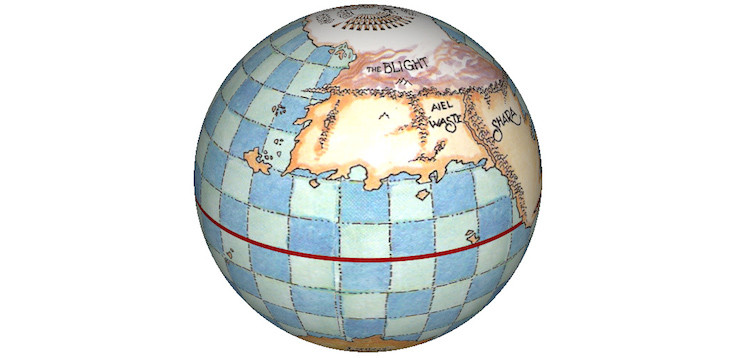
But the Wheel of Time takes place on a globe—on Earth, in fact—and while idly coming across Ellisa Mitchell’s world map I suddenly wondered… how close was Shara to the Seanchan continent? And would it have made sense for Seanchan to invade Randland from the east, instead of the west, as they do in the novels?
It’s a little tricky to figure out. The world map itself is obviously stylized and not meant to provide an exact scale, more of a rough approximation. But it’s the only indicator we have of the size and location of the world’s continents, so it will have to do.
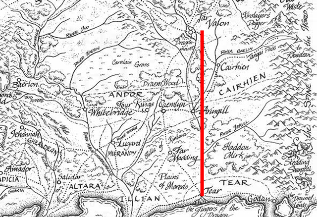
Our quest would be over if the stylized world map was our only resource, but thankfully Jordan himself offers exact land measurements throughout the series. In New Spring, Tar Valon is said to be located exactly 400 leagues north of Tear if you traveled in a straight line. The Wheel of Time Companion has this to add about an ocean voyage between Altara and Illian.
Arran Head: A promontory at the western end of Kabal Deep in southeastern Altara. Between Arran Head and the city of Illian lay a hundred leagues of open water, across the mouth of Kabal Deep. Rand speculated that the Seanchan needed two weeks to reach the border of Illian from Arran Head.
(Oh hi there, sneaky WoT Companion excerpt!) Braem Wood is also roughly noted as being located 50 leagues north of Caemlyn. These three distances are a good mix of both long and short lengths that are large enough to see on the map of Randland. They’re comparable to each other, as well, which allows us to judge the accuracy of the measurements.
Here’s Tar Valon to Tear.
The distance from Arran Head to the coast of Illian should be one-fourth of that. Does it work out?
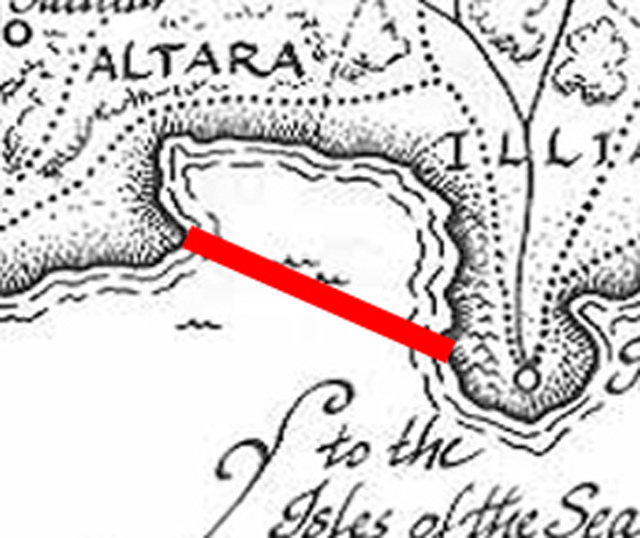
It actually does! Depending on where a ship lands, it’s 85 to 115 leagues from Arran Head to Illian’s shores. And Arran Head direct to Illian is roughly 100 leagues, as we see above. Half of that red bar should mark the distance of 50 leagues between Caemlyn and Braem Wood.
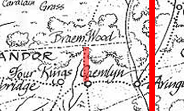
That also works out! So now we know we have a measurement that can be applied not only to Randland, but the world at large. Let’s see what the distance is between Mayene and the longitude that Falme is at, since those are the most identifiable features on the world map’s version of Randland.
It’s 2.4 times as long from Mayene to Falme longitude as it is from Tar Valon to Tear, meaning that the width of the Randland portion of the continent is 960 leagues. Now that we know that, we can determine how long the entire continent is, from Falme to the eastern coast of Shara.
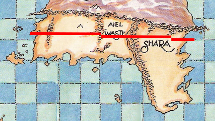
Looks like the entire western continent is 2.3 times as wide as Randland itself, which means that the continent is 2208 leagues wide. Now it’s Seanchan’s turn on the scale! Even though the Seanchan continent is wider in the southern hemisphere, I’m measuring its width at the same latitude that Falme is at, since that’s where the initial Seanchan forces landed. (i.e. They probably launched from that latitude, as well.) The Aryth Ocean (otherwise known as the World Sea) is enormous, so the Seanchan would have wanted the shortest route possible.
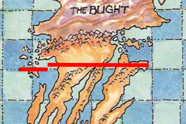
Looks like northern Seanchan is 1.29 times as wide as Randland itself, which means that it’s 1235 leagues wide.
Uh oh.
At first glance, the width of the continents doesn’t seem like a problem, and really they aren’t. But then you need to factor in the width of the Aryth Ocean/World Sea, which is given as 3000 leagues wide in the books. Since Jordan’s given measurements actually agree with each other, we have no reason to believe that his given length of the Aryth Ocean is inaccurate. So in total, the width of the known world from the western shore of Seanchan across to the eastern shore of Shara is 6443 leagues.
And that still isn’t a problem, actually. Until you take into account the length of a league in The Wheel of Time, as stated in The World of The Wheel of Time. In the “Big White Book,” as it is known, author Teresa Patterson gives the length of a league as 4 miles, which would make the distance from west Seanchan across to east Shara 25,772 miles.
The Wheel of Time takes place on Earth, which has an equatorial circumference of 24,901 miles, 871 miles smaller than what we just measured. If a league in The Wheel of Time really is 4 miles long, then Seanchan and Shara should be right on top of each other.
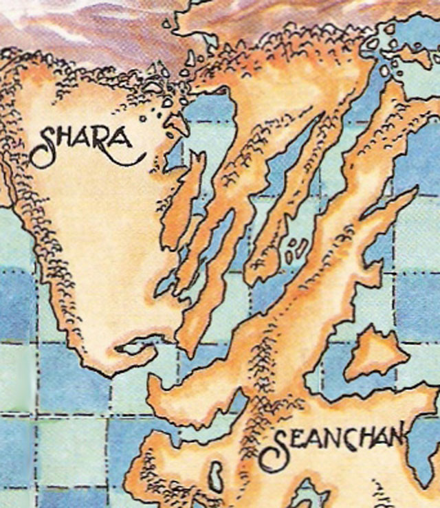
And they’re not, since the Morenal Ocean sits between them.
(Briefly, I wondered if differences in sea level could account for the larger planetary width, but it looks like even if all planetary ice caps melted it would only add 500 feet to the planet’s width. That’s not even close to the 871 mile discrepancy. Plus, the map shows the Earth’s ice caps as present.)
The only way we can fix this discrepancy is by discarding the stated length of Wheel of Time leagues as inaccurate. The “4 mile” length isn’t directly stated by Jordan, but relayed through another author, Patterson, who at DragonCon in 2005 explained that the book contains purposefully vague information in keeping with the “legend fades to myth” nature of the series. In fact, a league has never been measured as 4 miles throughout history. It’s not even measured as 4 miles in the world map itself, as the 3000-mile scale included doesn’t equal a 12,000 mile wide Aryth Ocean.
So let’s propose that a league in the Wheel of Time is actually the same length as a nautical league is measured today: 3.4 miles. This gives us a new length from western Seanchan to eastern Shara of 21,906 miles.
Which means that the final unmapped piece of the world of the Wheel of Time–the Morenal Ocean between Shara and Seanchan–is 2995 miles across.
Now we can make a map that shows ALL the land on Earth during the events of The Wheel of Time.
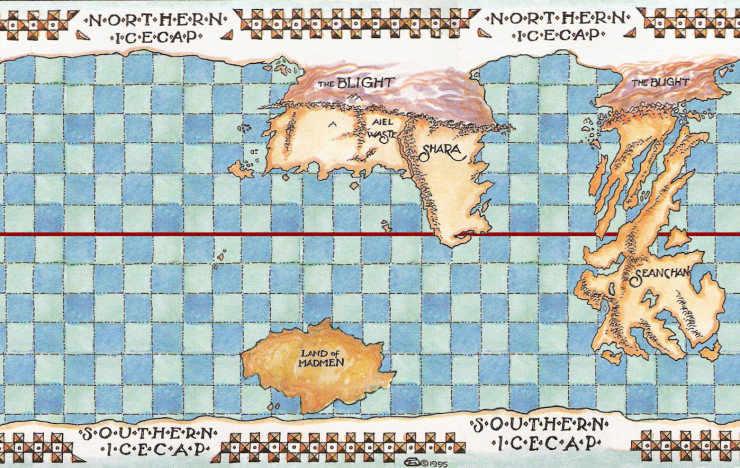
As we see, the expanse of ocean between Shara and Seanchan is still considerable and explains why the Sharans and the Seanchan probably didn’t interact throughout the history of their cultures. The travel distance is roughly equivalent to the distance between the Azores to the Dominican Republic, a distance that took a leap in ship engineering technology for us to master.
We know that the Seanchan possess that kind of engineering know-how, since they arrive in force across an ocean that’s three times as wide, but its origin is uncertain. There are two possibilities:
- The Seanchan’s divided nation and city-states develop this technology on their own and sail east and west. They find Shara first, but instead of a technologically inferior people they find a reclusive united country that is combatitive against foreigners, resulting in the loss of the Seanchan’s explorative fleet, or at the very least a very persuasive argument against spending money and resources attempting a second voyage to Shara.
- It’s also possible that first contact with Seanchan is what initially motivated Shara to become reclusive and combatitive against foreigners. Even if the Seanchan laid waste to the people, as Cortes did to Mexico, Shara obviously eventually repelled the Seanchan invaders and its culture continued onwards, so the end result is the same whether the Seanchan were destroyed or not upon first contact with Shara.
- The more likely possibility is that Seanchan did not have their longship technology until it literally arrived in the form of Luthair Hawkwing’s fleet. After all, it took Artur Hawkwing unifying Randland to even get that kind of ship technology developed, and Seanchan wasn’t unified until after Luthair arrived. If this possibility is how Seanchan history played out, then it explains why Seanchan didn’t invade Shara post-Hawkwing, as Luthair’s death set the gaze of Seanchan culture eastward.
That eastward expectation may be the only explanation we have for why Seanchan didn’t cross the much, much smaller Morenal Ocean in order to invade Randland. Even though they would have to go around the horn of Shara, the trip is still about 3000 miles shorter. But hey, Luthair didn’t come from that way and there was no guarantee for the Seanchan that their ships could even reach Randland from that direction. What if there was another land mass between Shara and Randland that extended south and barred the way? Or what if Shara patrolled those seas?
In the end, the answer as to why Seanchan invaded from over the Aryth Ocean is simple: the wheel weaves as the wheel wills. The Seanchan went east because this was the only way Rand could win the Last Battle. If the Seanchan had gone west they would have arrived at Tear before Rand did, meaning Rand may never have managed to obtain Callandor, and we all know how key that item ended up being in the final battle!
It’s a funny world, that Wheel of Time.
Watch for more Wheel of Time Companion and Spin the Wheel coverage through this tag.
Chris Lough writes a lot for Tor.com, you see.
What about sargassos & trade winds? That is to say, maybe it is farther as the crow flies, but faster as the ship actually sails?
I think they sailed that way because it is where they came from. They weren’t really interested in an economic sense, they wanted to restore the Empire.
I’m not sure trade winds would be a consideration with channelers present. The Sea Folk honed their manipulation of sea winds for centuries, and while the Seanchan probably didn’t have that level of sophistication, I imagine they would have attempted some way to brute force their ships through sargassos and against trade winds.
I wish I knew enough about weather patterns and ocean currents to be able to suss out thermohaline circulation and intercontinental currents, though. Figuring out where the jet streams are would have interesting implications for the various weather disasters that occur in the series.
On a spherical world, you’re assuming that after a 3,000 league journey a fleet would land at the same latitude as that from which it embarked?
From a navigational point of view for any latitude other than the equator, no. Just… no.
Any distance over 600 nautical miles you leave behind plane sailing (in which you basically assume the world is flat because it makes the maths simpler) in favour of great circle sailing (pick a circle that goes through the centre of the earth, stick to it unless you hit something) to get the shortest distance. Sitting on a single latitude for that distance without a major consideration such as trade winds or currents is just stupid.
Chris–
Thanks for crunching the numbers and providing a very interesting global geography analysis.
I suppose if the hailene and corenne had sailed west, but left a few months later than they actually did, then they wouldn’t have arrived in Tear before Rand. Meh.
They named the expedition “The Return”. According to Tuon, the Seanchan weren’t expecting to actually need to conquer all the Randland. They thought they would be greeted by a Hawkwing Empire still functioning and they would then unite to fight the Last Battle on Randland. The expedition only turned from “redeploying armies before the Last Battle” to “conquering a continent” when they noticed that there was no Hawkwing empire anymore.
On a spherical world, you’re assuming that after a 3,000 league journey a fleet would land at the same latitude as that from which it embarked?
In a practical sense, no. As you say, the actual route the Seanchan took across the Aryth Ocean would be circular, but I needed to know the shortest possible route in order to confirm the width of the ocean, and that would be latitudinal. I found that while Aryth wasn’t exactly 3000 leagues, it was close enough that I felt comfortable continuing to extrapolate the width of Seanchan and Morenal.
The great circle route problem has already been pointed out, but the glossaries of the books make it clear that WoT miles are shorter than Imperial System miles, so your calculations for the circumference of the Earth are also wrong.
Do you know what latitude Randland sits at? Without that, there is no accurate way to gauge distances longitudinally. 50 leagues in Tear would look shorter on the map than 50 leagues in the Blight, or even Tar Valon.
Following the same latitude isn’t the shortest distance between two points on a sphere (except at the equator). For example, if you look on a flat projection map at the shortest distance between North Carolina and Morocco, both at about 35° North latitude, the line representing that roughly 4000 mile path will curve up to about 45° N.
Seems like y’all are arguing that it may actually have been a shorter distance for the Seanchan to travel the direction they did: east to west. Anybody care to refine Chris’ first approximation?
The circumference of the Earth is indeed 24,901 US customary miles (same as Imperial) +/- whatever natural variation and measurement error.
From the glossary in TGH: 1 Randland mile translates to 6000 Randland feet, and 1 Randland foot = 10 Randland inches. If we assume (can anyone verify?) that Randland inches are the same length as US customary inches, then 1 Randland mile = 5000 US customary feet, which is indeed shorter than a US customary mile.
Wasn’t this explained in the book? Hawkwing sent an army to conquer the Seanchan and one to conquer Shara. If tuon legitimately believe she was the heir of hawkwing, she probably wouldn’t want to rouse any additional claimants to the throne.
Or maybe they invaded from the west because it’s the direction they came from…
Someone wrote a whole article on this?
Um, using the equatorial circumference in this way doesn’t work. You’re measuring a circle around the world at the latitude of Falme. That circle is noticeably smaller than the equator if it’s as far north as it looks. Your final map is likely a good approximation of the globe, just given the narrative exigencies involved, but that just means the randland league is shorter than these estimates.
3. TorChris
Sometime remind me to show you the ocean & wind current sims I’ve tried to build for my campaign.
I will mention that it is much easier to navigate along a given latitude. Knowing longitude is mush more difficult and requires more and better equipment.
Aren’t there also hospitable islands eastwards between Seanchan and Randland? Would make for easier progress to island-hop and resupply to a presumed welcome than to land on a hostile shore, potentially fight through a whole tonne of marath’damane, and then get to the Homeland.
Reference: Suroth’s scenes, TGH.
Another possibility of why they didn’t sail from Seanchan’s west coast: infrastructure. From comments across the books, we’ve gathered that Seanchan’s standing army has been fighting constantly this last millennium. In fact, Karede’s man from the Cassite hillmen were only conquered within the last 20 years or so, or at least within living memory, if I remember correctly. Perhaps the infrastructure and order in the west coast weren’t securely enough under the Crystal’s Throne’s control to attempt that sort of large-scale expedition.
The Hawkwing-descended forces arrived on the east coast, so it’s likely those regions are their oldest established, most secure and most industrial areas, the best place to plan, build and supply essentially moving an army and substantial colonial force across an ocean. This isn’t the colonization of the Americas, after all, which came in fits and starts and seeded along spots along the coasts. This is movement on a massive, Exodus from Egypt scale. They NEED their most advanced and secure facilities to do this, and the still-contested or at least if not rebellious then surly west coast would not provide what they need. The East coast also likely holds their greatest population concentrations, and thus would likely most benefit from getting people out of there and across the ocean.
Also, even accounting for the Breaking, Randland has too much water. Hopefully the Companion will account for the seemingly missing landmass. If the Land of Madmen is Australia, and it likely is, for its shape alone, then Ranland and Shara definitely need more volcanoes, since it’s in the Pacific Ring of Fire.
What happened to Africa? Is its sinking where the Atlantis legends come from?
If the Land of Madmen is Australia, Antarctica is missing, too.
Seems easier to sail a potentially wider ocean than bring an entire army across Shara, a mountain range, the generally inhospitable Aiel Waste, and another mountain range (I’m reminded of the various attempts to invade Russia from Europe, although that was winter, but still)… and it may end up being faster despite the longer distance since there is less land to travel across.
I don’t think Chris was saying invade Shara. I think he was saying sail around its south tip and land at Tear/Mayene.
I still think the way the math was done doesn’t account for flat vs projection maps.
@19 What happened to Africa? The Breaking of the World. The fallout from every single male channeler of the Age of Legends going nuts at once canonically reshaped the geography of the world itself.
My theory on why the Seanchan invaded from the direction they did is basically that they outright knew that there was something back that way and possibly didn’t know what was in the other direction. The infrastructure possibilities brought up by @18 would also play into it.
I think the reason (other than “The Wheel Weaves as The Wheel Wills”) is what posts #2, 13 and 23 said: It is the direction they came from, they knew people and land were back that way, and that is where they knew they needed to go eventually, so that is where they went.
As for why they didn’t send anything the other way; their entire history is about conquering that continent with very short breaks of peace here and there. They were very busy.
@15, you (and others) may be interested in this real-time simulation of global wind patters: http://earth.nullschool.net/
You over looked the plots of the Forsaken. The sharans were under the sway of Demandred and Semirhage had serious weight in the Seanchan court, enough weight to slap Toun when no Seanchan would dare look her in the eye except Selucia and enough weight to kill the whole royal family. And the Dark One was probably keeping the Sharan Channeler’s as the surprise weapon that they became in the Last battle and Tuon was suppose to die after the death of her family, and with Suroth in Charge of the Return, the Forsaken would have been in charge of the Seanchan as well at the final battle, but Mat foiled all that when he kidnapped Toun and ended up as Commander of the Seanchan army and see the part they played in saving everyone’s hide after the Great Captains got rolled. I think the Dark One did not want two surprise weapons fighting each other when he would need them for the last battle.
In the glossary of TFOH (maybe others too, but that’s what I have at hand), a league is indeed defined as 4 miles, but the miles are nonstandard:
1 league = 4 miles = 4,000 spans = 24,000 feet = 240,000 inches
They don’t mention whether inches are standard, if they are, a league would amount to about 3.79 miles (or 3.29 nautical miles).
In chapter 32 of ‘The Fires of Heaven’ Rand and Aviendha travel to Seanchan. When they leave the igloo that Rand made it says that the sun was just starting to rise in the east. When they get back to Cairhein, Asmodean states that dawn will arrive in a couple of hours. For this to work, Seanchan would have to be right on top of Shara. The assumption that they had spent their time in the Southern Hemisphere of Seanchan (there was snow when Rand land was in summer) helps a bit, however, days being shorter in the winter and longer in the summer due to the tilt of the earth would allow some leeway, yet not enough. Seanchan would have to be an a diagonal tilt from north east to south west for this discrepancy in the rising sun. Or Jordan wasn’t really thinking things through properly.
As the article states, there would have been too many unknowns about sailing around the Horn of Shara. And their navigation would have had to have been very precise, to avoid landing in any unknown territory, such as the 3-fold land, which the Seanchan would have known almost nothing about. But by invading the West Coast of the continent, they would have been assured of landing in some part of Hawkwing’s former empire, even if they didn’t get to Falme first. Again, it was the way Luthair sailed, so they would have been more inclined to sail back the same way.
Yeah, without any compensation for the map projection, this is just fantasy. And seeing as the author thinks latitudinal routes are the shortest on a globe it becomes even more fantastical. Also there seem to be no hazards to travel in the authors mind. Shara being an united empire since almost the breaking, while Seanchan has been united for a couple hundred years plays no role, either.
I also fail to understand why Luthairs death would set their eyes eastward, his arrival and domination of the continent would’ve done that.
Remember the community at Falme called the Watchers of the Waves who were tasked with keeping an eye out for the return of Luthair’s armies. This corroborates the theory that Seanchan eyes would indeed be set eastward. And if their industrial centers were in fact on the east coast of the continent, the fleets traveling south and west around the southern end of Seanchan to toward Shara would add its own extra travel time (assuming no ports or infrastructure were ever
built on the west coast). Finally, though it’s a shorter distance, the Morenal Ocean it still basically the same or similar width as the Atlantic Ocean; not exactly a short swim ;-)
This may not be relevant to the overall theory, but you said that it was stated that 4 miles is a pleasure, but that doesn’t compute. I’m reading the series and in EotW, ch 34, Mat is grumbling and mentions “4 miles to a league.” So, while he could be rounding up, that’s probably where the information was retrieved.
I feel that the argument that randland is set on earth is not that strong. The link that supposed to support that claim talks about inspiration from our myths and finds some links between names and current events. hardly strong evidence. A bigger planet is possible.