


I made a great number of discoveries while researching and writing Origins of the Wheel of Time. None of them changed my life quite like this one: the map was wrong.
Not the map of the Westlands that appeared in each of the main books in one way or another—sometimes in black and white, sometimes in glorious full color. That map, drawn by Ellisa Mitchell, remains as true to Jordan’s vision today as it was when The Eye of the World was published in 1990.
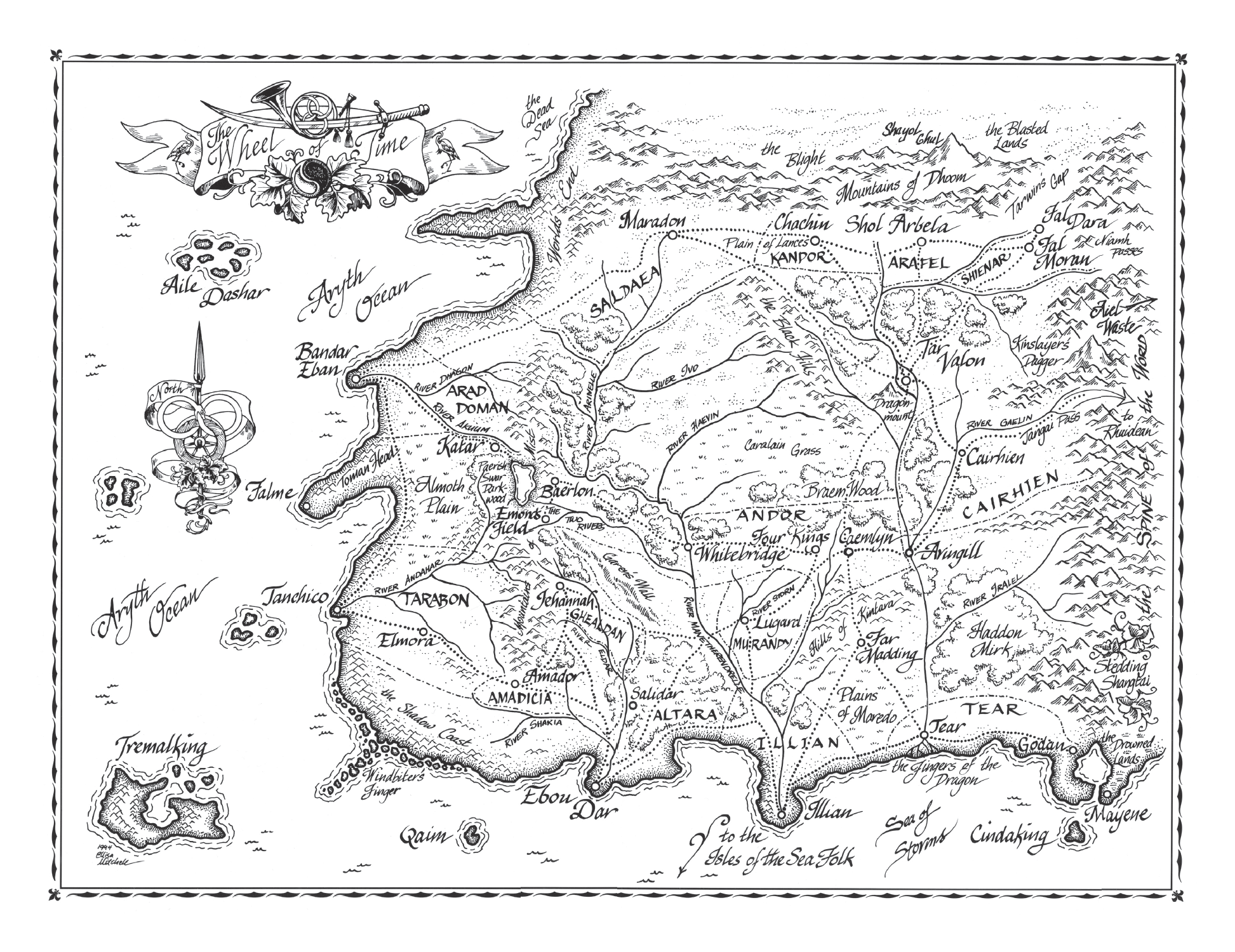
No, I mean the other map. The one of the entire world that was printed in The World of Robert Jordan’s Wheel of Time, a companion book to the series that was published in 1997—a book that fans call, somewhat affectionately, the Big White Book.
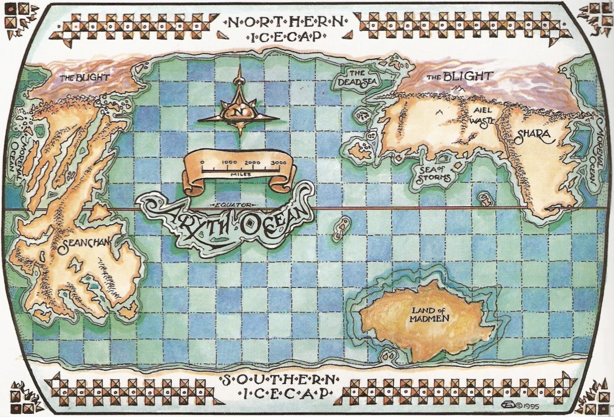
This map presents the larger picture of the Randland world: not just the Westlands where the main action takes place, but the surrounding continents and oceans, with the Aiel Waste, Shara, the Land of Madmen, Seanchan, and more Blights than you can shake a withered stick at.
There’s not a lot of detail on it, but I was still fascinated by this little map when it first appeared. I loved it not just because I loved the Wheel of Time and was desperate for any new information about the world that Jordan was building, but also because I simply loved maps.
It’s true. I’m a map aficionado. Among my earliest memories is spending hours combing through a huge, hardbound Atlas of the World, memorizing names and land features. Other early memories featured folded topo maps and compasses as I hiked the Rockies with my father, who worked for the US Geological Survey. Then, later, came Tolkien’s map of Middle-earth, which brought together a passion for cartography and a fascination with imaginary landscapes. Even in writing my own fiction, I always made the map first, knowing that action is defined by the ground on which it happens—a lesson I carried over to my current work finding and reconstructing ancient and medieval battles.
So a whole map of Jordan’s world? Gimme, gimme, gimme.
Fast-forward to late 2021, with me in a pandemic mask, poring through the boxes and boxes of materials in the archive of the Rigney Papers at the College of Charleston, researching my once-in-a-lifetime book on Jordan and his work. It was amazing.
Anyway, among the items in the archive are a series of folders from the writing of the Big White Book: drafts, edits, and correspondence between Jordan and the publisher. Like everything else, I went through the papers dutifully.
Much of it is the kind of thing you’d expect. Change this word. Be sure this illustration goes on this page. That sort of stuff.
But then I found pages showing drawings of the world map—the map exactly as it was printed, the map exactly as I knew it—and Jordan writing that it was wrong.
Wrong twice over.
First, there was the continent in the southern seas of Randland, one known for violent and unpredictable male channelers who’d turned the land itself into a chaotic, tortured sight. I’d already started writing about the origins of this place for my book, and I’d done so referring to it as the “Land of the Madmen,” because that’s what it was called in the Big White Book map. But here, going over that very same drawing, Jordan objected to the title. He did the same several times, in fact. One note to the publisher was remarkably succinct: “Land of Madmen is wrong. Should be The Mad Lands,” he wrote (Rigney Papers, Box 51, Folder 9).
So, yeah, there’s no “Land of the Madmen.” It’s “The Mad Lands.” Huh.
Second, there was the enormous continent of the Seanchan across the Aryth Ocean west of the Westlands. Here, the author’s concerns were literally larger. Commenting on the same world map—again, the map that I’d taken as canon from the Maker himself—Jordan wrote that the size and shape of the continent was incorrect: “extend Seanchan a little farther south. Make southern portion of Seanchan wider by 75%, all south of equator.”
This wasn’t just a label problem. This would be a truly world-altering change. So I assumed that Jordan must have changed his mind about it later in the publication process for the Big White Book. Surely they couldn’t have gone to print with a map so incorrect, right?
Well, I couldn’t find any indication that Jordan ever changed his mind. Instead, I found repeated pleas for the alterations, including a letter, written on November 25, 1996, stating firmly that the map “needs correction” (Box 32, Folder 2). Less than a year later, however, the erroneous map was in print.
About a month before I was working through these various notes in the archive, I had raised the idea of making a new world map for Origins, one that might show a bit more detail than the one in the Big White Book. Now, I went back to Harriet and the Estate with a further ask: if we made a new map, should it match the published one or Jordan’s notes?
I was strongly of a mind that we owed it to Jordan to get it right, but I knew this wasn’t a small ask. Not only would a corrected map make the Big White Book in error, but it would also affect The Wheel of Time Companion, published in 2015, which had been overseen by Harriet and Team Jordan. That book referred to “The Land of the Madmen” throughout. So I was asking to reshape canon.
The Estate said to do it. Even more astonishingly, Tor immediately got Ellisa Mitchell herself contracted to draw it, so that our new and more accurate map of Randland would match her much-loved map of the Westlands in style. It was an amazing sequence of emails to get, I assure you.
Almost immediately, though, my mind turned to a whole series of big questions.
Putting a new label on a continent was easy, but how exactly did we reshape one? Jordan said to “extend Seanchan a little farther south. Make southern portion of Seanchan wider by 75%, all south of equator.” Ok, but what should that look like? How far was “a little farther”? Should Seanchan grow wider to the east, the west, or both? What did this do to the shape of the coastlines?
For that matter, if we were making these kind of changes, should we make a few more, too? Jordan’s early notes described a major barrier reef on the eastern shoreline of Seanchan—one through which there was only a single navigable passage. I couldn’t find anywhere that this reef had fallen out of his plans, but I also couldn’t find confirmation that it had stayed in. So did we add that?
What about Ishamael’s Fortress? Given the materials that Jordan was working with, I had a very strong sense of where it should be, but I had no smoking gun to say for sure. Should we add it?
And what about fixing some of the errors in the Seanchan topography that Jordan hadn’t noted? For instance, some of the river routes sketched into the map in the Big White Book defied the laws of nature (and, I’d argue, of physics, too).
For that matter, what about adding more detail of roads and rivers in Seanchan? Or in Shara? I had whispers of where some of these things might be located, but I hardly had all of them.
I outlined all of these questions and more in a letter to Harriet, the Estate, and the folks at Tor, written on the last day of 2021. With the caveat that my vote didn’t really count, I offered up my suggestions and my rationale for them. I didn’t think we should add in roads in Seanchan, for instance, “as we’d be adding whole cloth at that point,” I wrote, “but if Harriet wants it done I will absolutely do whatever I can to help make it happen.”
The next day, the calendar turned to 2022.
Not a week later, I was told it was up to me.
I know I must have kept breathing when I read it, but I don’t recall doing so … and I don’t really know how I could’ve managed it. It was remarkable enough that I was writing Origins, after all. As I’ve said, I couldn’t call the book a dream come true because I never would have dared to dream of it. And now—Light help me—I was tasked with reshaping the world of the Wheel of Time.
Not figuratively. Literally.
And so I sat—at Jordan’s desk, surrounded by Jordan’s notes—and sketched out the changes that I thought should be made. As with everything else in Origins, my sole determination was to get it how Jordan would have wanted it. I did it with an open heart, a full mind, and an enormous spread of books and papers, but I also did it with an aim to err on the conservative side of the possibilities.
Buy the Book
Origins of the The Wheel of Time
A lot of Origins worked this way, in fact. There are things we have from something Jordan clearly said or wrote. As long as he didn’t later contradict these tidbits, they’re 99% likely to be true. (I’d say 100%, but statisticians would surely object!) A step down from this are things that I’m maybe 90% sure of: we don’t have that smoking gun from the author, but they pretty much have to be true. And so it goes, with lesser and lesser odds until we get to those things that I think are there but I can’t back up with much more than a hunch and a feeling.
When it came to writing Origins, I packed my contracted word count with the information that I could support to a very high degree. In so doing, I left as much of myself behind in order to favor the surety of Jordan’s vision.
So when it came to the map, I didn’t add any of the roads in Seanchan or elsewhere. I didn’t include Ishamael’s Fortress (I’d call my odds on that around 75%). I didn’t add the barrier reef, either. As I wrote at the time:
The barrier reef was part of the original materials, yes, but [Jordan’s] more mature notes on Seanchan run to several hundred pages—and I can’t find them referenced anywhere in there. This, plus the fact that he didn’t make note of adding them when he asked for the changes to the continent map, makes me inclined to think he’d changed his mind on why more ships didn’t make the crossing.
As for what the continent should look like, I first tackled the question of which way the southern portion should be made wider. Looking at the map he was commenting upon, going wider to the west would have taken the continent clean off the map. I felt reasonably confident that Jordan would have mentioned the need to expand the map in that direction if that’s what he was wanting. Since he didn’t, the widening of Seanchan would need to occur within the map, and that meant going east. Doing so, I noted, would also have the effect of making the continent’s coastlines “fit” better with those of the Westlands and the Waste—a suitable mimic of plate tectonic results in our own world, like the way that South America and Africa can stitch together.
Additionally, going east made sense to me because it would help resolve something that had previously been a bit of a mystery to readers: why did the Seanchan cross the wide expanse of the Aryth Ocean to get to the Westlands when the distance to reach them was seemingly less across the Morenal Ocean? At least part of the answer was that Seanchan was much closer than the published map had shown.
What about the coastline shapes and everything else? Well, Jordan had objected to the proportions of southern Seanchan, but he hadn’t said things were otherwise wrong. The most reasonable move, then, was to “stretch” the existing map eastward below the equator. I sketched this out and it was sent along to Ellisa.
I made a few other changes. I felt confident that those rivers that ran against nature on the Big White Book map were “artistic flourishes rather than [Jordan]-approved topography,” as I wrote at one point. Sure, I didn’t have anything directly from him saying they were wrong, but given everything I knew of the man, I felt certain he wouldn’t let them stand. He’d simply not said anything about it at the time because he was trying to get the far bigger problems fixed first.
It would have been nice to make major alterations to the Seanchan landscape. It was such a mess to my eye that the temptation was real. In the end, though, I again opted for making the smallest changes to the precedents that would nevertheless resolve the problems with them. I was, as I said at the time, “trying to thread the needle between respecting them and making them make sense.”
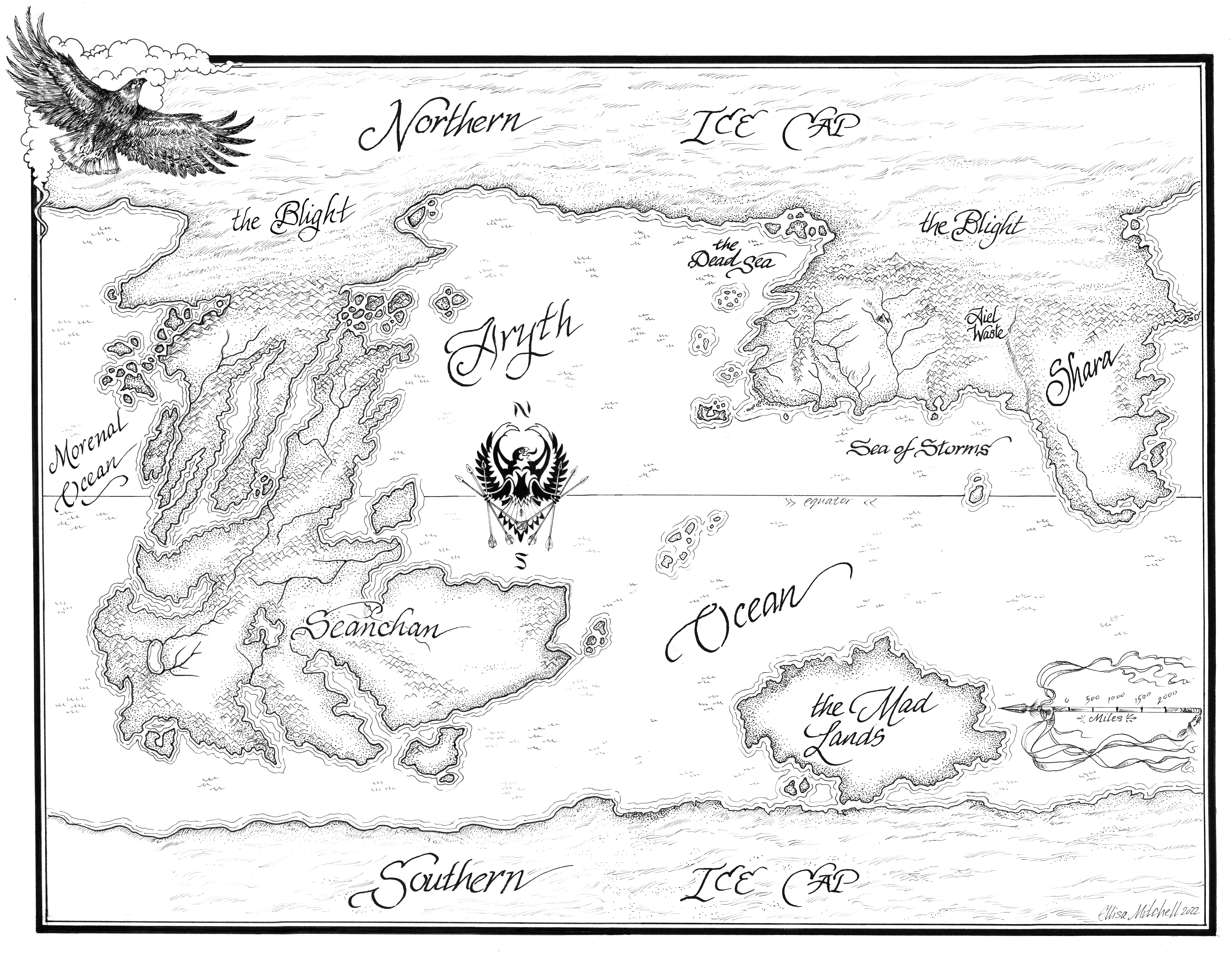
Keen eyes comparing the two maps will see—through the lens of Ellisa’s amazing artwork—how I made modifications in the least intrusive way I could. If I was starting from scratch with Jordan’s personal approval, I’d absolutely remake the topography in more significant ways, but no matter how often I was told things were up to me, I simply didn’t want to go that far. All of this, of course, was going through checks by the Estate, though I can’t think of an instance where they didn’t give a thumbs-up. The message at one point from Jordan’s assistant, Maria, was “Anything that Mike suggests is good by me”—which blew me away.
I’m sure a lot of folks are reading this and imagining how exciting it would be to have such a hand in re-making Randland. From the outside, I might well say the same thing.
But the truth is that there’s a lot of weight in being made a Maker in a made world that you respect and love. I think inevitably one feels a sense of impostor syndrome.
This is something I talked about with Brandon Sanderson at one point, trying to get a handle on how he managed it. I won’t speak for him, but I’ll say that for my part I made peace with the fact that at every turn I had done the best I could, that Harriet and Maria—and seemingly everyone else who was ever involved in the Wheel of Time—had checked my work, and that I’m certain that Jordan’s desk would’ve up and crushed me if I’d gotten it wrong.
That is, after all, how magic tends to work.
–Michael Livingston
The Citadel
What a fascinating and enlightening read! Thank you for sharing the story! After reading this, I am sure whatever change was made was only for the best and Robert Jordan himself would have approved as well. Can’t wait for the Origins!
Fans have another name for the 1997 book: The Big Book of Bad Art. I bought the book on initial release…and returned it within days. The art is, overall, staggeringly bad; I didn’t and don’t blame RJ or Teresa Patterson. The publisher is the one who chose the budget and artists. I’ve kept a faint hope that at some point TOR will redo the book and be willing to fund art that’s of a matching quality with RJ’s incredible story.
Origins, though, looks to be really interesting. I’ll be checking it out.
If you were to place the WoT world map over a map of our time where might it line up (if it even would)? Seanchan over the Americas. the Lands where most of it is set over Russia and Asia, or parts or even none of these? This begs the question.
I had hopes when I saw this title that perhaps, just perhaps, you were fixing the geographical impossibilities that are all over the maps. Alas, no.
I couldn’t finish the series and the poor, impossible, maps were part of it.
Good luck with your book. I hope that it helps those who are fans of the series, enjoy it even more.
I wonder if there’s enough material to publish a Wheel of Time Atlas. Adam Whitehead has made significant strides in trying to create a narrative (and general) WoT atlas for his Atlas of Ice and Fire blog (using Steven Cooper’s chronology), including calculating the sizes of all the Westlands nations. Between Michael’s work here and the others it seems like there’s more than enough material for it. And having a dedicated Atlas would be a vast improvement over both the Companion and the White Book.
@5 What’s geographically impossible for hundreds of madmen reshaping the landscape with the One Power?
Oh Michael, I am so flipping excited for Origins!!!!
I just had my birthday, and my hubby gave me his receipt for my copy since we all have to wait an unbearable amount of time (only 2 months now, right? Squeeee!) for it to come out. :D
Also for my birthday, he had gotten the whiteboard map on auction at JordanCon this year (I started crying, what a wonderful gift for a map dork like myself!!!) and I found myself wondering if you had used that whiteboard at all (probably not since you had much more detailed notes) when you were working on the book. A nerd has got to nerd, and I’m a nerd, so…. :-)
Will the new map in your book have a foldout spread? Or is it a map we can unfold and frame and hang up?
I saw a google maps style WoT map on reddit ages ago, it was great fun, I hope you saw it, being the map lover you are.
Thank you for the update, here’s looking forward to November and the new book!!!!
If we are using Michael’s revised map, I would like to now where on the Seachan continent they launched the Forerunners. Based on the map Michael created, the be somewhere along the Southern land mass. This is the farthest eastern point in the Seanchan empire. However, if they did launch from here, the most direct route would have had them make land in Tarabon rather than Falme. Hopefully, Michael will discuss which port he thinks the Forerunners left from.
@9 I’d assume sea currents would have an impact on their landing too. Easiest to go with the current, and if it’s pushing you a bit north, oh well.
I see Baltezaar @3. got there ahead of me.
a book that fans call, somewhat affectionately, the Big White Book.
That book, indeed, has been called disaffectionately The Big Book of Bad Art by fans…
Yeah – I have never heard anyone refer to it as the “Big White Book”, just “The Big Book of Bad Art”. I understand the desire to be diplomatic but if you’re not going to use the real nickname, better to just leave out that aside entirely.
This is so amazing and awesome and I am so excited to read your book, thank you!
Thank you for explaining this. I appreciate knowing how much work went into the new map and it’s wonderful to hear the original map artist updated it. I admit I intensely disliked the “Big White Book” when it came out and have never used it as a reference for anything since. This sounds as close as we can get to what Mr Jordan actually intended.
I admire the intent behind this new map but it appears to have made the opposite error of The World of Robert Jordan’s The Wheel of Time: Seanchan is now far too big rather than significantly smaller than it should have been.
As per Robert Jordan’s notes on the subject, Seanchan is about 6,000 miles wide at its widest in the south. The old map made it between 4,000 and 5,000 miles wide, so too narrow. This new map makes it over 9,000 miles wide in the south! So it’s now far too wide. Ironically, placing the original map on a sphere (via a website like maptoglobe) makes Seanchan somewhat thicker south of the equator, as does using the smaller-scaled map of Seanchan and overlaying it on the world map instead of the world map version (which is out of proportion with the other map of the continent in the same book!), which also makes Seanchan thicker. If you do all of that, Seanchan more or less reaches its correct size (i.e. the world map was inaccurate but the actual continent map of Seanchan in the world book appears to have been correct).
It’s also worth noting that it was always RJ’s intent that the Aryth Ocean be insanely massive. In his notes it clearly states that Falme straight west to Seanchan is 11,000 miles (whilst it’s less than 3,000 miles from Seanchan to Shara via the Morenal Ocean/Sea of Omerna).
It’s worth noting there are also additional locations around Seanchan which can be discerned via the text: Maram Kashor is the island off the SE coast (as noted in Knife of Dreams), Marendalar is the largest island off the coast (so thus likely the one on the equator near Shon Kifar), leaving by elimination Salaking (as the southern extreme of the continent) as the island off the SW coast.
@6: Yes, there’s certainly enough material to do a proper Wheel of Time atlas. That is without question at this point. I must admit I broke off my project in The Shadow Rising because it became clear that Steve Cooper’s timeline, although excellent, had made little allowance for the realistic distances humans could cover in a day and by TSR it had become quite untenable. I should get back to it and maybe abandon the attempts to fit the journeys into a timeline, and of course it’s not long after that it ceases to be so much of an issue as everyone teleports everywhere.
I have read all the books several times (as a matter of fact on this very moment I am reading again). At the end, when Rand is walking into the world, I desperately want to know how the story would develop further. I feel all the characters from the book became friends and I want to know how their lives continue.
Can anyone write the next book?
Kees Maat
@16: Without Robert Jordan, and with his notes for the post-WoT world being nonexistent (only one line exists from the planned Seanchan sequel trilogy: “Mat was playing dice in a back alley in Ebou Dar,”) this would be a bad idea and would merely be fanfiction.
The west coast is the dad from Family Circus
I’d also add that Robert Jordan may have indeed decided “The Mad Lands” sounded better between Tom Canty finishing the map and the book being published, but the publishers decided they couldn’t afford to redo the whole map and RJ seemed fine with that, and from the publication of the book in 1997 to his passing in 2007, he exclusively used the term “Land of the Madmen” and used that in his notes, conversations, interviews, Q&As with fans etc. He didn’t seem to think of it as a big deal and just went with the published term.
@15, it’s somewhat important to note that RJ redefined the Mile for WoT. It’s not the ~5,400 imperial feet we’re used to. I can’t recall the exact measurement but a quick search of the main WoT sites should dig that out.
Fascinating, thanks! I too love maps, my library is covered in sepia ones from my favorite books/games. And I pre-ordered your book, looking forward to it :)
So where is Ishamael’s fortress? Hyping it up just to not even say, what a letdown. 75% certainty is worth at least elaborating on.
@20: True, but RJ also used “mile” very inconsistently through the books. Sometimes he uses “his” mile and sometimes he uses “our” mile, and then in out-of-universe discussions and notes and communications with artists, it wasn’t always clear what he was using (I think the assumption was the “real” mile if it’s not an in-text reference). The world map is definitely using “our” mile, though, because it’s equatorial diameter matches up with the real Earth’s.
I also super want to know where you think Ishamael’s Fortress is!
The fastest route for a sailing ship depends more on the winds than the distance. There’s a reason why the permanent easterly winds between the tropics are called trade winds. To sail eastward, especially if your ship is square-rigged, you want to be in the mid-latitude cell between 30° and 60° north or south. Those are stormy waters with variable winds, but westerly winds dominate, so you don’t have to beat to windward the whole way.
Crossing the equator adds considerable uncertainty. Ships can be becalmed for weeks in the doldrums, using up food and water while waiting for wind.
Furthermore, stretching the globe into a rectangle makes the northern part of the Aryth Ocean look much wider than it is. Even more so if the map stretches the oceans disproportionately in order to avoid distorting the continents too much.
Thus, if they could choose where to start from, some port on the northeastern coast seems like a better choice than the southern part of the continent. Ships returning westward should take a more southerly route, near the Tropic of Cancer, where they can follow the northeasterly trade wind.
If the mountains and coastlines seem crazy or broken, then that’s because they were shaped by madmen in the Breaking, so that’s fine. (Rivers still won’t run uphill of course.)
I’m afraid the new map doesn’t help any with finding a point in southern Seanchan where the sun can be seen rising out of the sea a few hours before it rises over Cairhien.
In chapters 31 and 32 of The Fires of Heaven, Aviendha and Rand Travel from Cairhien to a place with mountains to the west and a sea to the east. It’s winter there while it’s summer in the Westlands, and they meet Seanchan people, so they are in southern Seanchan. By Rand’s estimate, it’s about two hours before midnight when Aviendha opens the gateway. The sun rises just when they begin the trek back to the gateway. When they return to Cairhien, Asmodean says it’s two hours before dawn. No map I’ve seen really supports that timing. Extending southern Seanchan westward would make it easier to reconcile the map with the timing constraints.